

Regenerative native forest
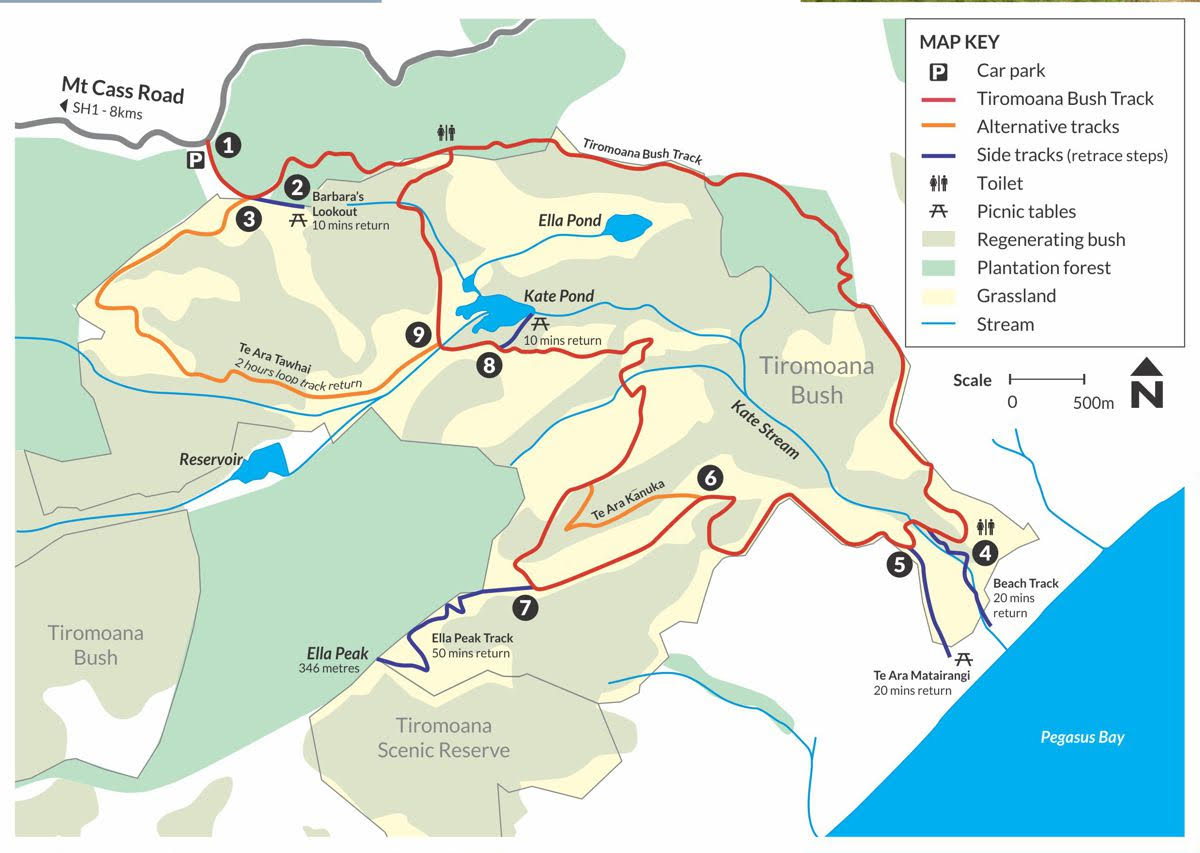
The Tiromoana Bush Walkway is a great way to experience being in a regenerating native forest complete with ponds, wetlands, and native birds as your companions. The Walkway travels through open farmland with sweeping views over the forest and the coastline to Pegasus Bay, Motunau Island and the Pacific Ocean. Walking the complete loop track takes approximately 3 hours.
Walk through native bush to an unspoiled beach
Your journey begins at the car park on Mt Cass Road (1 – see map), about 8kms from SH1 in Waipara. At the car park there’s an information display. The main walkway travels across plantation forest. The track to Barbara’s Lookout (2) is signposted about 5 minutes from the car park. Climb through the deer fence (via a people gate) and walk 500 metres to the lookout with views over Kate Valley to the coast. There’s a picnic table to sit at while enjoying the view.
The main track descends past the remnant and regenerating native forest of black beech, five-finger, kahikatea, kānuka, kōhūhū, lacebark, mānuka, ngaio, ribbonwood and tōtara, down to Kate Stream by the coast. From there it’s 10 minutes along a track by Kate Stream to the beach (3).
Take a track that leads to a lookout
Alternatively head up the hillside and take a track that leads to a lookout – Te Ara Matairangi (4).
Local Māori Runanga, Ngāi Tūāhuriri, who has mana whenua (customary ownership) over the area designed and built an ika pou whenua (mahinga kai fishing marker) at the walkway’s coastal lookout. The carvings on the pou reflect cultural values and relate to the importance of the area to Ngāi Tūāhuriri and for mahinga kai (resources that come from the area). The lookout view takes in Motunau Island to the north, the sweep of Pegasus Bay and Banks Peninsula to the south.
Climb to a peak or enjoy a seat by a wetland
The track winds back through the forest, with sidetracks through a steep gully of regenerating kānuka (5) and to the lookout at Ella Peak (6). Though a steep climb over 1.5kms to the top of Ella Peak, the 346metre high hill rewards you with panoramic views from Christchurch to the Kaikouras.
The main track descends to the valley floor before looping past a picnic spot by the wetlands at Kate Pond (7), surrounded with harakeke/flax. Once seasonal wetlands that dried out in summer, water management at the upstream landfill ensures a flow of water year-round enabling vigorous plant growth at Kate Pond and a habitat for birds, including rare species such as the spotless crane.
An enjoyable half-day’s adventure
The main track ascends through the forest and rejoins the track along the ridgeline in the plantation forest. An alternative track Te Ara Tawhai (8) takes a longer gentler climb through the forest back to the main track and the car park (1). Te Ara Tawhai is a loop track that starts at the Barbara’s Lookout junction and descends to join the main track in the valley. This is also a great option for a short walk with a stop for a break at the Kate Pond wetland before following the main track back to the car park. Walking the 5.2 kms loop of Te Ara Tawhai including a short stop at the Kate Pond wetland will take 2 hours for the return walk.
Everything you need for a rewarding and enjoyable half-day’s adventure in North Canterbury’s own regenerating native forest can be found in Tiromoana Bush.
Panoramic views over vineyards and limestone formations
The Mt Cass Walkway offers panoramic views over the vineyards and limestone formations of the Waipara - Omihi Valley, the peaks and bush filled gullies of the Mt Cass Range and the coastline of Pegasus Bay and the Pacific Ocean from Motunau Island to Banks Peninsula.